
Travel in Ecuador with Volcanoes and Amazon Rainforest - INTI Tours
On the trail of Alexander von Humboldt
Ecuador - small but mighty! With just under 300,000 square kilometres, Ecuador is the smallest of the Andean countries in South America. However, due to its location directly on the equator and the strong differences in altitude in the country, it has an extreme diversity of natural areas in a very small space.
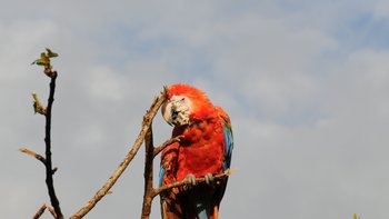
Experience cloud forest, beautiful beaches on the Pacific coast, the "Road of the Volcanoes" with its colourful birdlife on our tours in Ecuador. You can enjoy beautiful beaches and roam the species-rich Amazon rainforest. Along the way, you can stay in wonderful lodges and historic haciendas and shop in lively markets. You can climb volcanoes and experience the jungle by canoe from the river.
It is not for nothing that the German polymath AIexander von Humboldt was so enthusiastic about Ecuador and wrote in a letter to his brother Wilhelm: "The high snow-covered peaks, the active volcanoes, its vegetation and the customs of its inhabitants make the region the most interesting in the world".
Ecuador also includes the animal paradise of Galápagos - a UNESCO World Heritage Site and certainly a dream of all animal lovers. Let yourself be overwhelmed by the many facets of this state on the equator.
Welcome to Ecuador!
Country information Absolutely worth seeing Facts and figures Travel in Ecuador Addresses
Unsere Reisearten in Ecuador
Examples of individual dream trips in Ecuador

Ecuador individually: Galápagos island hopping
Galápagos is unique and cannot be compared to any other place in the world. Observing and spending time with animals that feel no fear of humans is one of the most intense experiences of all.
15 days Bestseller 1 up to 6 travellers
upon request

Individual Ecuador Tour with Amazon and Galápagos
Experience the natural paradise of Ecuador with its snow-capped volcanoes, evergreen jungle and the unique Galápagos Islands. Discover the highest active volcano on earth and the paradisiacal flora and fauna in the deepest jungle of the Amazon basin.
27 days Individualreise 2 up to 6 travellers
upon request
You might also like this...
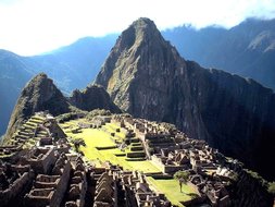
Peru and Bolivia: The History of the Sun People
Bolivia & Peru - One-Rail Romance I: Follow the traces of the Incas through Peru and Bolivia mostly with romantic, exotic and "Andean" train rides. Especially for railway enthusiasts, this trip will be an unforgettable experience.
20 days Bestseller 6 up to 15 travellers
upon request

Peru North and South: From enigmatic advanced civilisations of the north to the empire of the Incas
Embark on a journey to the enigmatic advanced civilizations of northern Peru and learn about the legends of the powerful Moche, Lambayeque, Chimú and Inca rulers.
16 days Bestseller 6 up to 12 travellers
upon request
Peru Experience the Land of the Incas - Option I
The trip "The Land of the Incas - Varinate I" is suitable for those who visit Peru for the first time. It dives deep into the region of the Incas around Cuzco and the Sacred Valley.
12 days Bestseller 2 up to 12 travellers
upon request

Peru Experience the Land of the Incas - Option II
The trip "The Land of the Incas - Variant II" is suitable for those who visit Peru for the first time. Two days Machu Picchu lets you intensively experience this highlight of all Inca sites.
12 days Bestseller 2 up to 12 travellers
upon request
Country information on ECUADOR: „Diversity in a confined space“
When Ecuador broke away from "Greater Colombia" in 1830, it chose a great name in reference to its special geographical location on the equator: Ecuador!
Although the small Andean state only owns a good 500 kilometres of the equator line, which covers more than 40,000 kilometres, its equatorial location does indeed give the country its special character. This, in turn, was recognised as early as 1802 by the German explorer Alexander von Humboldt, when he travelled through Ecuador on the west-east axis and was the first to attempt to record and explore the many natural regions. He spoke of "a journey around half the earth" on comparatively only a few kilometres. "Diversity in a very small space" is probably the best way to describe the country, and this is also what makes Ecuador so appealing to visitors. It is not easy to divide Ecuador into large natural areas, as each of these regions has its own characteristic microclimates due to special phenomena (ocean currents, proximity to the equator, soil conditions, winds, mountain ranges as watersheds...).
The whole of Ecuador lies near the equator in the inner tropics. This means that in the course of the year there are only very slight fluctuations in temperature and climate, but the temperature fluctuations within a day - depending on the altitude - can be very extreme. This is referred to as a "diurnal climate".
The size of Ecuador varies: without Galápagos the country today covers about 263,000 km², with Galápagos about 271,000 km². In 1942 Ecuador had to cede almost 175,000 km² of Amazon lowlands to Peru! Ecuador's new border since then is still not really accepted today, which is why the border courses in Ecuadorian and Peruvian maps vary. In Ecuadorian maps, the old borderline is even marked in bold, while the current borderline is only faintly marked. Ecuador is smaller than the FRG and is considered the smallest Andean country. It borders Colombia in the north, Peru in the east and south, and the Pacific Ocean forms the natural border in the west. Roughly speaking, Ecuador can be divided into four major natural areas:
1. Costa: western coastal lowlands, which cover approx. ¼ of the country's surface area.
2. sierra: central Andean highlands, also covering about ¼ of the country's surface area
3. oriente: eastern Amazon lowlands, covering almost half of the country's total area
4. Galápagos: island archipelago of volcanic origin, which rises 1,000 km west of the Ecuadorian coast in the Pacific Ocean.
Capital Quito:
Quito is Ecuador's capital, the administrative and government seat of the country, and the most important transport hub. The population is currently around 2.7 million people - a colourful mixture of peoples with huge social differences. Quito is often referred to as the city of eternal spring, with summer (June - November) and winter (December - May) experiencing all the seasons we know, e.g. spring warmth in the morning, sunny heat at noon, sleet showers and cold wind in the afternoon. The day and night hours are almost exactly the same all year round. All this comes from Quito's special geographical location: Quito is just south of the equator at 2,850 m.a.s.l. and it is surrounded by protective hills and mountains.
The city can be clearly divided into two areas: firstly, the old town in the south with all its historical buildings and churches, which is the home and living space of the poor population; secondly, the new town in the north with modern high-rise buildings, banks, commercial buildings, hotels - the home and living space of the wealthy Quitenos. The link between the new and the old town is formed by parks. In the past, these were the cattle pastures and agricultural areas of the Quitenos. Since 1996, Trole buses have connected the old and new town. In the new town you can see many stately villas from the end of the 19th/beginning of the 20th century, where the wealthy private population withdrew from the old town to live in their private palaces. Today, these beautiful buildings often house consulates or embassies, museums, hotels, restaurants, universities or private clubs. The New Town - apart from its scenic surroundings - could be anywhere on earth.
The old town is quite different, where one really feels transported back to colonial times. Since the Spanish conquest, the church has shaped the cityscape, religiousness dominates the alleys and streets. 18 churches, often with attached monasteries, rise in the immediate old town centre next to administrative buildings, squares and street markets. UNESCO declared Quito's old town a cultural heritage of humanity in 1978, and since then money has flowed into the city coffers for restoration purposes. The city's landmark is the Panecillo with the "Virgen del Quito", the city's patron saint, towering over everything.
Absolutely worth seeing:
- Quito's old town is a must-see with its beautiful and lively squares Plaza San Francisco and Plaza de la Independencia. Small markets, crowded alleys, magnificent colonial houses, beautiful churches, cafés and countless street vendors make great photo opportunities and invite you to stroll around.
- The Palacio del Gobierno with the Ecuadorian state flag also rises here, as does the monumental Mudejar-style cathedral from 1667.
- The colonial church La Compañía de Jesús looks rather inconspicuous from the outside, but inside the Jesuit church is almost completely decorated with gold and very imposing.
- About ten minutes from the old town is the Basílica del Voto Nacional, known less for its interior than for the great view of the Centro Histórico and the Panecillo hill. The climb up the towers is adventurous. You should be free from giddiness - the fabulous view is worth all the effort!
- On the hill Panecillo with the famous winged statue of the Virgin Mary, you can enjoy the view of the city and the overwhelming volcanoes Cayambe and Cotopaxi. Important: Only take a taxi up there!
- The Centro Cultural Metropolitano behind the Plaza de la Independencia houses impressive exhibitions. The photographs, sculptures and paintings mostly refer to indigenous culture and current social issues in Ecuador.
- Easy to reach from the new town is the Mirador Guápulo, which offers a fabulous view of the Cumbayá Valley.
- La Capilla del Hombre is the artistic life's work of the Ecuadorian artist Oswaldo Guayasamín, whose works deal with the suffering and poverty of the indigenous population of South America.
- The equatorial monument La Mitad del Mundo rises a good 20 kilometres north of Quito. Not only is the equator line said to run here, but the "centre of the world" is said to be located here. Since Charles-Marie de La Condamine took a slight measurement in 1736, the actual equator lies 240 metres north of the monument according to current measurements.
- In the immediate vicinity of the old town, a cable car leads to the Cruz Loma mountain station at 4,050 metres above sea level. From the mountain station you can continue hiking to the summit of Rucu Pichincha (4,698 m.a.s.l.).
Ecuadorian Coast - Costa:
In the coastal lowlands, marine sediments cover extensive areas as a result of distant sea floods. Mangrove forests form the transition from land to sea, inland palm forests form the natural cover. Today, the approx. 100 km wide coastal lowland strip with huge cultivation areas for coffee, bananas, cocoa, rice... is mainly used for agriculture. The Rio Guayas in the south is the largest river in western South America. The coast of Ecuador forms a climatic bridge between the driest region of South America in the south (coastal desert of Peru/Atacama Desert) and the Colombian Pacific coast in the north as the wettest region of the continent. Accordingly, the northern Costa is wetter, the southern drier.
Absolutely worth seeing:
- The Ecológica Cayapas-Mataje Reserve covers 500 km² and is located in the far north of the coast. Near San Lorenzo, it boasts the highest mangrove trees in the world and is especially busy with birds in the morning hours. Princesa Täri waterfall and picturesque border village of Mataje.
- Cotacachi-Cayapas Reserve, which, with an area of 2,500 km², is the largest protected, species-rich area in the western Andes. It ranges from a few metres above sea level to almost 5,000 metres above sea level and is home to rainforest, mountain cloud forest and páramo - and thus all the altitude levels and vegetation zones found in Ecuador. By motor canoe on the Río Borbon, you can reach Chachi Afro communities in the middle of the rainforest along the riverbank lined with palm trees and mangroves. The Pacific Ocean, which is under the influence of a warm water current here, has a constant temperature of 26-28 °C all year round.
- Etwas weiter südlich findet man die Strände von Muisne, Mompiche und Portete. Größter Küstenort ist Pedernales. Ausgedehnte feinsandige Sandstrände, malerische Fischerdörfer, Garnelenzuchten und Mangrovensümpfe wechseln sich ab.
- Along the so-called Spondylus Route you will find wonderful fine sandy beaches, hidden nature reserves and several villages where the famous Panama hat weavers live and work. Hidden bays invite you to visit mangrove forests and Corazón Island with one of the largest frigate bird colonies in Ecuador. In the Machalilla National Park with the offshore island of La Plata, you can observe excellent humpback whales from June to the end of September.
- Wave surfers get their money's worth in Montañita.
- Frigatebird Island Manglecito from El Morro
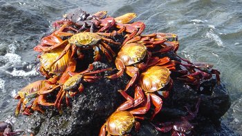
- South of Guayaquil is the Archipiélago de Jambeli - a true bird and mangrove stilt paradise. Blue-footed boobies, frigate birds and pelicans as well as sea lions, sea turtles and dolphins can be observed.
Ecuador's Andean region - Sierra:
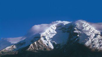
Nowhere else on earth are volcanic peaks as close together as in Ecuador's Andes, with 9 of the total of 30 volcanoes considered active. The Andes Mountains in Ecuador run in two parallel main chains - the Western and the Eastern Cordillera, separated by a central longitudinal valley. Alexander von Humboldt called the longitudinal valley south of Quito the Road of Volcanoes. The famous, shapely Cotopaxi rises in the Eastern Cordillera and, at 5,897 metres above sea level, it is considered the highest active volcano on earth! Ecuador's highest mountain - the 6,310 metre high Chimborazo - stands in the Western Cordillera.
The longitudinal valley between the two mountain ranges is in turn divided into eight inner-Andean highland basins, which lie between 2,000 and 3,000 metres above sea level. River systems have cut into the sedimentary and volcanic deposits of the basins, creating breakthrough valleys for drainage east to the Amazon or west to the Pacific. Today, the most important road connections to the coast and the eastern lowlands are laid out there.
Absolutely worth seeing:
- Quito - the capital of Ecuador.
- The Reserva Ecologica Cayambe-Coca is one of the most beautiful national parks in the northern Sierra and is ideal for a hiking trip in combination with a visit to the Papallaca thermal baths, as one of the entrances is a short distance above the thermal baths.
- El Àngel National Park is located in the border area to Colombia in the vegetation zone of the high páramo. The flora is fascinating, especially the millions of frailejones (Espeletia pycnophylla) that characterise the landscape.
- The Otavalo market is considered the largest indigenous market in South America. On Saturday mornings it starts with the cattle market and later and on other days everything imaginable is offered from food to handicrafts to clothing and weaving.
- Near Otavalo, below the Cotacachi volcano, lies the Cuicocha lagoon, around which you can take a wonderful hike (approx. 20 km, approx. 5-6 hours) along the crater rim of the caldera.
- Laguna Quilotoa is also a spectacular crater lagoon with the possibility to hike along the crater rim.
- Train ride around the devil's nose Nariz del Diablo starting from Riobamba to Alausí.
- Next to Quito, Cuenca is a beautiful colonial city whose old town area is also a UNESCO World Heritage Site.
- Ingapirca, not far from Cuenca, is the most important Inca site in Ecuador.
- Hiking in the Cajas National Park, located about 30 km west of Cuenca and founded in 1977.
- Hiking in Cotopaxi National Park below the highest active volcano in the world, Cotopaxi at 5,897 metres above sea level.
- Visit to Chimborazo National Park with hiking opportunities below the 6,310 metre high volcano with best opportunity to observe alpacas, llamas and vicunas. Chimborazo is the highest mountain in Ecuador.
- The Sangay National Park, with a size of 517,765 ha, includes the three Ecuadorian volcanoes Sangay (5,230 m.a.s.l. - active), Tungurahua (5,023 m.a.s.l. - active) and El Altar (5,319 m.a.s.l. - extinct), in addition to a varied flora and fauna. It is a UNESCO World Heritage Site.
- Baños is located on the stretch between the Andean highlands and the Amazon lowlands at a pleasant altitude of 1,802 m.a.s.l. It has sulphurous thermal springs and is an ideal starting point for active tourism - bicycle tours, rafting, hiking etc. are offered.
Ecuador's Amazon lowlands Oriente:
The climate here is hot and humid all year round under the influence of the south-east trade wind, with the most rainfall in the country, averaging 2,000 - 3,000 mm a year (locally even 4,800 mm). At the equinoxes in March and September, when the sun is above the equator, the heaviest rains fall - mostly short, heavy tropical showers. Average annual temperatures are 26°C, although the heat before the rain is extreme and the temperature can drop as low as 10°C after the shower. Ecuador is a plant paradise. The tropical rainforest of Amazonia is the richest in species, with botanists assuming that 2/3 of all plants on earth can be found here! The sun is high in the sky all year round, temperatures are high all year round and rainfall is also high all year round. In addition to this climate, the nutrient-poor soils of the rainforest zone contribute to Amazonia's biodiversity. On an area of one hectare (= 100 x 100 metres), up to 200 plant species from different families can easily be found, but it is difficult to discover even one plant of the same species within a radius of several 100 metres! Over 70% of all rainforest plants are trees that can live well over 200 years. In the tropics, the trees have no annual rings. At 20-30 metres above the ground, the treetops form a closed canopy, which is broken by individual giant trees up to 55 metres high.
Absolutely worth seeing:
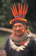
- Visit a rainforest lodge with various excursions on foot and by boat. Local knowledgeable guides explain plants, discover wildlife and make contact with indigenous groups and shamans. The most important protected areas in the Ecuadorian Amazon rainforest are the Yasuni National Park and the Cuyabeno Reserve. These areas have a fantastic amount of wildlife, as well as rainforest corridors that connect the rainforest so that animals such as jaguars, monkeys and tapirs can go from one reserve to another. Various birds can be seen from the observation towers.
Galápagos Islands:
The Galápagos Islands are an archipelago in the eastern Pacific Ocean. They lie about 1,000 kilometres west of the Ecuadorian coast and form a province of their own with their capital Puerto Baquerizo Moreno. The extraordinary and unique flora and fauna of the islands are UNESCO World Heritage Sites. They are protected by the Galápagos Islands National Park. Approximately 97% of the surface area of the Galápagos Islands and 99% of the surrounding waters are strictly protected. All economic and tourist use is strictly regulated and very much controlled by the national park administration in Puerto Ayora.
Absolutely worth seeing:
Galápagos in itself is absolutely worth seeing! There are two different ways to visit the islands. What the individual prefers is a matter of taste.
- You can go island hopping and then make excursions from the respective locations to the individual places. Especially good for people who like to travel individually. Advantage for people who get seasick easily.
- Or you can take a Galápagos cruise, where the ships usually cover longer distances at night so that individual islands can be visited during the day. The advantage of this is that you can visit a larger radius overall. There are various options for the ships - from small motor ships with up to 16 passengers, sailing ships or larger ships with up to 100 passengers.
Facts and figures Ecuador:
Land area: 283,561 sq km
Population: just over 17 million - There are very different population groups living in Ecuador, but it is difficult to state the respective size. As in other Andean countries, the proportion of indigenous people is very high. On the one hand, this can be explained by the dense settlement by indigenous populations under Inca rule. On the other hand, only Spaniards migrated to Ecuador, but hardly any other Europeans. Estimates speak of 40% indigenous population, 40% mestizos, 10-15% people of European descent, 5-10% Afro-Ecuadorians.
Capital: Quito with about 2.7 million inhabitants
Highest mountain: Chimborazo, 6,310 metres high
Form of government: presidential republic
History: Ecuador's history can be divided into three major eras: First, the indigenous epoch; second, the colonial epoch; and third, the republican epoch. The indigenous peoples once maintained trade relations as far as Central America and the Amazon lowlands. They operated coastal shipping as far as southern Chile and probably even reached Galápagos, 1,000 km in the Pacific, with their deep-sea rafts. Sebastián de Benalcázar founded the Spanish city of San Francisco de Quito in 1534 on the ruins of an ancient Inca city. In a short time, other cities were founded to demonstrate Spanish supremacy. Further development was largely determined by the Catholic Church and its influence was reflected in politics, art and education. The indigenous population was enslaved and in some areas almost exterminated. The Spanish crown created various viceroyalties in its young colonies. On 23 September 1830, the independent Republic of Ecuador was constituted. - From the beginning of the Republic of Ecuador, a kind of regional rivalry developed within the country, which equally led to a political division into two large camps. Thus, we are dealing with the conservative camp in the Andean highlands and the liberal camp on the coast.
Economy: Ecuador is the fourth poorest country in South America in terms of GDP per inhabitant according to purchasing power parity. The country's economy is heavily dependent on oil production, which accounts for almost 60 % of exports. Since the late 1980s, cut flowers have been grown in Ecuador on a large scale for export; Ecuador is the fourth largest exporter of cut flowers. Besides cut flowers, bananas, fish and shrimps, metals and machinery, and coffee also play a minor role alongside oil production. Tourism has also developed into an important economic sector.
Currency: US Dollar
Language: Spanish
Festivals: Every year, every village and town celebrates the founding festival in honour of the local saint for several days. This is a festival where the whole population celebrates and parades dressed in traditional costumes take place.
Carnival is celebrated by throwing balloons filled with water or flour. In Ambato, on the other hand, a big flower festival takes place at the same time.
The spring equinox on 21 March is celebrated at the Equator Monument and in Otavalo together with the Coya Raymi festival.
The Easter festival of Alangasi is celebrated magnificently.
The annual Inti Raymi in Ingapirca at the solstice celebration on 21/22 June is celebrated extensively by the indigenous Cañari.
The festival in honour of Peter and Paul in the province of Manabi on the coast of Ecuador on 29 June.
Yumbada of Cotocollao in the north of Quito on 4 July
Los Rodeos Montubios - the bullfights of the Montubios, an ethnic group in the hinterland of the coastal region in the provinces of Guayas and Los Rios on 12 October
Christmas parade El Pase del Niño in Cuenca
In many places, the figures of the "old year" are symbolically burnt as dolls made of paper and cardboard on New Year's Eve to start the new year "fresh".
Travelling in Ecuador:
Entry requirement: The passport must be valid for six months at the time of entry. Failure to meet this criterion will result in refusal of entry followed by return to the airport of origin. Entry with damaged passports may lead to rejection by the border police. German nationals do not require a visa for entry and stay of up to 90 days per year. The entry stamp is obligatory, even when entering via the land border of Peru or Colombia. If you violate Ecuadorian residence law, you can expect severe penalties, including deportation custody in the case of continued illegal residence. The passport or a copy of the passport must be carried at all times. It is also recommended to carry a copy of the entry stamp and the above-mentioned insurance.
For visits to the Galapagos Islands, since February 2018, the presentation of a return ticket and hotel reservation for the planned duration of stay is also required.
Vaccinations: No compulsory vaccinations are required for direct entry from Germany. A valid yellow fever vaccination is required for all travellers over the age of 12 months entering from Brazil, the Democratic Republic of Congo and Uganda, as well as for travellers who have spent more than 12 hours in transit of one of these countries. For travel to the designated yellow fever infected areas of Ecuador, especially the provinces east of the Andes below 2,300m (Morona-Santiago, Napo, Orellana, Pastaza, Sucumbios and Zamora-Chinchipe, Esmeraldas), vaccination is strongly recommended for all travellers over the age of 9 months. Coming from Ecuador, vaccination may be required for onward travel to a third country (e.g. onward travel to parts of Costa Rica).
Climate/Travel time: Ecuador can basically be visited all year round. As far as Ecuador's climate is concerned, its location on the equator leads to large temperature fluctuations. In fact, from a climatic point of view, there are not four seasons, but only two, with more or less precipitation. Thus, especially in the highlands, there are strong temperature fluctuations with sunny mornings and rainy afternoons. In the Amazon basin and in the northern coastal lowlands, it is hot and humid, with rainfall decreasing from north to south along the coast. Generally, the driest months are June to November, with the best bathing weather from December to May. It is quite different in the Galápagos Islands: Here it is usually very sunny in the first half of the year with a water temperature of 23 degrees and only a few tropical rain showers. In the second half of the year, on the other hand, the dry season prevails.
Local time: The time difference between Germany and Ecuador is (CET) -6 hours, during summer time the time difference is -7 hours. (CEST)
Addresses:
Ecuadorian Embassy in Berlin
Joachimstaler Straße 10-12
10719 Berlin
Telefon: (+49) 30 8 00 96 95
Fax: (+49) 30 80 09 69 699
info@ecuadorembassy.de
https://botschaft-konsulat.de/ecuador-botschaft/