
Tours in Guatemala to jungle, volcanoes and ancient culture - INTI Tours
On the road in the green land of the Mayas
Guatemala - right here lies the geographical centre of the American double continent. When travelling in Guatemala, mighty temples, colourful culture, colourful markets, colonial cities and overwhelming scenery inspire.
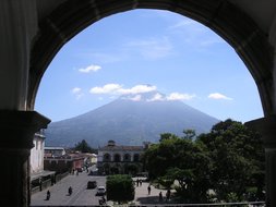
33 volcanoes, green overgrown mountains, hilly coffee plantations and the fascinating lush green jungle will fascinate you. The panorama of Lago Atitlán is considered unique in the world, as three volcanoes give it a grandiose backdrop.
Nowhere in Central America are there such colourful, varied weekly markets as in Guatemala and they are always a feast for the eyes. The market in Chichicastenango is particularly colourful and exciting, with all its smells, sounds and colours.
Your visit to the best-explored Mayan city will be unforgettable: Forest - tropical lush green rainforest - and in the middle of it all, the towering pyramids and structures of Tikal. The location in the middle of the jungle is unique, the dimensions are immense.
Welcome to Guatemala!
Country information Absolutely worth seeing Daten und Fakten Travelling in Guatemala Addresses
Our types of travel in Guatemala


Examples of individual dream trips in Guatemala

Individual tour to Guatemala, Mexico, Honduras and Belize
Marvel at the fascinating world of the Maya, immerse yourself in the cultural and scenic highlights and travel through primeval rainforests, to seething volcanoes and to tropical dream beaches.
18 days Rundreise 1 up to 10 travellers
upon request
You might also like this...


Country information on GUATEMALA: „Forested land of the Maya“
Guatemala is located south of Mexico's Yucatán Peninsula. It borders Mexico to the complete north, Belize to the east, Honduras to the southeast and El Salvador to the south. Guatemala has narrow access to the Gulf of Honduras in the east and thus to part of the Caribbean Sea. In the southwest, the Pacific coast borders the country. In Guatemala, more precisely in the city of Cuilapa, lies the geographical centre of the American double continent. In the heartland of the Maya, mighty temples, a lively and colourful culture of various indigenous tribes, colourful markets, magnificent colonial cities and an overwhelming landscape inspire: 33 Volcanoes, mountains, coffee plantations, high plateaus and the fascinating lush green jungle with the unforgettable Mayan ruins of Tikal, Uaxactún, Dos Pilas or Aguateca.
Capital Guatemala City:
Guatemala City, a metropolis of over a million inhabitants, was one of the first Mayan cities and later the trading centre of the Spanish colonists in Guatemala. In the city centre, the ruined site of Kaminaljuyú points to the ancient city roots from the Mayan era. Three earthquakes are responsible for the fact that almost all the old classical buildings no longer exist. The country's largest metropolis has many museums worth seeing; the Museum of Modern Art and the Textile Museum of Indian Clothing are worth highlighting. Certainly, the visit to nearby La Antigua Guatemala is the biggest attraction. It is located not far from Guatemala City in the highlands and was the capital of the Spanish territories in Central America in colonial times. La Antigua's old town has a unique baroque and colourful colonial architecture and is a UNESCO World Heritage Site.
Absolutely worth seeing:
- La Antigua – the old capital and baroque jewel in the highlands
In the north of Guatemala:
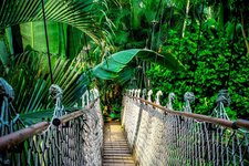
Towards the north, Guatemala's mountains gradually become flatter and eventually reach the lowlands of the Yucatan Peninsula. The part of the Yucatan Peninsula that falls on Guatemala is called Petén and is flat or slightly hilly. The southern area has numerous plantations. Due to lower rainfall and the special soil conditions, a pine savannah thrives on a relatively small area in the region around Poptun. The north is still extensively covered by tropical, always humid rainforest.
Absolutely worth seeing:
- Forest - tropical lush green rainforest - and in the middle the rising pyramids and buildings of Tikal. A visit to this best-researched Mayan city touches, fascinates and remains unforgettable. Tikal is considered one of the largest and most powerful Mayan capitals in the world. The location is unique, the dimensions are immense: the entire area extends over 65 square kilometres. The central area alone, with about 16 square kilometres, has over 3000 buildings! Recent estimates have shown that in its heyday, almost 50,000 inhabitants populated the city. The centre is the "Great Square", which is framed by the North Acropolis and two temple pyramids. The history of the city, its rulers and deities were once elaborately decorated on the many stone steles that can be marvelled at today. The historic Mayan city was rediscovered early on and intensively researched as early as the end of the 19th century. The entire area around Tikal was declared a national park by the Guatemalan government.
- The so-called Maya Trek is located in the Maya Biosphere Reserve. For three days, this hike leads through wonderful nature past witnesses of Mayan times to the Tikal National Park. A unique experience for hiking enthusiasts.
- Uaxactún is located only about 20 km north of Tikal and was integrated into the Tikal National Park together with the Maya sites El Zotz and Yaxha in 1982. It is one of the earliest Mayan historical sites and has very well preserved wall drawings in addition to pyramid buildings.
- The Mayan site of Dos Pilas with its fine stone carvings.
- There are no huge pyramids in Aguateca, but the structures found are considered the best preserved Maya ruins in the country.
Guatemala's south:
The southern part of the country can be roughly divided into two regions.
First, there is the central mountain region with agricultural land, mountain rainforest, cloud forest and the so-called paramo. Paramo" is the term for the high mountain vegetation in the humid tropics. Numerous volcanoes, some of them active, also dominate the landscape. In the east of the mountain region it becomes drier and briar savannah dominates the picture.
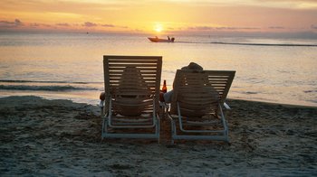
Secondly, the Pacific lowlands are now largely cultivated with plantations. The original vegetation was lowland dry forest, which changes to cloud forest at higher altitudes. The Pacific coast itself is lined with dark sandy beaches, the vegetation consists of palms, mangroves and beach almonds.
Absolutely worth seeing:
- One of the most spectacular places in southern Guatemala is undoubtedly Lago Atitlán. The panorama of the lake is unique in the world, because three volcanoes give it a grandiose backdrop. The volcanoes are the 3,000 m high San Pedro, the 3,085 m high Tolimán and the highest of the three - Atitlán - at 3,480 m. All three volcanoes can also be climbed. All three volcanoes can also be climbed. The Atitlán is the third largest lake in the country and the result of a huge volcanic eruption. The lake has an area of 126 km², and in 1955 the entire valley was declared a national park.
- Nowhere in Central America are there such colourful and varied weekly markets as in this country, and they are always a feast for the eyes. The market in Chichicastenango is particularly colourful and exciting, with all its smells, sounds and colours. The church of San Tomas is the perceived centre of the town and the market, and women traders offer their flowers on the steps to the church in a particularly lively manner - a picture as if from another world.
- Quetzaltenango - also called Xela for short - has a beautiful city centre and a strategic location near the mighty volcanoes Siete Orejas, Cerro Quemado, Santa Maria and Santiaguito.
Caribbean region:
The extreme northeast of Guatemala offers tropical flair and a variety of flora and fauna. Compared to other countries, Guatemala has only a small share of the Caribbean. In the north, the Caribbean coast continues in Belize, in the south in Honduras. Nevertheless, the Guatemalan east coast is worth a visit! Close to the coast lies the Lago de Izabal, Guatemala's largest lake, which flows into the Caribbean Sea via the Rio Dulce. A special breed of people emerged here through the mixing of former West African slaves with the Carib people and developed an independent music and dance culture as well as a unique cuisine.
Absolutely worth seeing:
- A boat trip from Livingston on the Río Dulce upstream to Lago de Izabal. To the left and right of the river, dense green jungle grows, interrupted from time to time by small wooden huts where locals live their simple lives.
- Livingston is located directly on the Gulf of Honduras and is as full of life as the people in this part of Guatemala.
Facts and figures Guatemala:
Land area: 109,000 sq km
Population: 16 million - approx. 58 % mestizos and 40 % Mayas
Capital: Guatemala City with approx. 5 million inhabitants
Highest mountain: Tajumulco (4,220 m) - stratovolcano
Form of government: Presidential Federal Republic
History: The Mayan country was conquered by Hernán Cortéz in 1521. Guatemala has been independent from Spain since 1821.
Economy: Guatemala is the largest economy in Central America. The main exports are still traditional agricultural products such as coffee, sugar cane, bananas and cardamom.
Currency: Guatemalan quetzal
Language: Spanish
Festivals: Semana Santa (Easter week) in Antigua, Indian market of Chichicastenango every Sunday and Thursday
Travel in Guatemala:
Entry requirement: The passport must be valid for at least 6 months upon entry, at least for the duration of the planned stay.
Vaccinations: No compulsory vaccinations.
Climate/travel season: Year-round travel season. The climate is tropically warm on the coast, cooler to cold in the mountains depending on altitude. Best time to travel: The dry season is from December to April. Rainy season is from May to October. Hurricane season is from September to November.
Local time: -7 hrs.
Addresses:
Guatemala Embassy
Joachim-Karnatz-Allee 45 - 47, 10557 Berlin
Tel. 030/2 06 43-63, Fax -659
www.botschaft-guatemala.de
www.visitguatemala.com