
Travel in Peru through beautiful natural areas - INTI Tours
On the Road in the Land of the Sun People
On our tours in Peru you will experience Machu Picchu, Cuzco and the Sacred Valley of the Incas as well as the coastal region of northern Peru and the Amazon rainforest.
Peru - that is first of all the land of the Incas. Machu Picchu, as probably one of the most fascinating archaeological sites in the world, awakens a longing in us to explore and discover the ancient and mysterious. And yet the Sacred Valley of the Incas, all these mystical special places around Cuzco are only a small part of this multifaceted country.
All the other highly developed cultures before the time of the Incas also tell stories that sometimes seem incredible, sometimes simply fascinating. Let yourself be enchanted by the weaving of the finest fabrics of the Paracas, by the mysterious desert lines of the Nasca, by the imaginative ceramics and the pyramids of the Moche, by the filigree gold work and the huge mud-brick settlement of the Chimú.
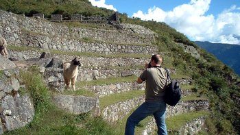
All this knowledge of the most diverse cultures finally culminated in the empire of the Incas, which fascinates people from all over the world. In Peru, you will also be surprised by dramatic natural scenery, ranging from the driest deserts on the Pacific Ocean to glacier-laden mountain peaks and down to the Amazon River. Wildlife ranges from seals and shorebirds to the camel species of llamas, alpacas and vicuñas in the high Andes and wild cats and macaws in the Amazon lowlands. The mighty condor circles above the Andean regions down to the coasts.
Welcome to Peru!
Country information Absolutely worth seeing Overview of the cultures of Peru Facts and figures Travel in Peru Addresses
Our types of travel in Peru


Examples of individual dream trips in Peru
Individual Peru Tour: Mysterious cultures
This trip combines fascinating cultural treasures of the north with the highlights of former Inca sites - for example the mysterious Chachapoyas towards Amazonia, the Moche or the Chimú culture on the Pacific coast and Machu Picchu.
21 days Individualreise 2 up to 6 travellers
upon request


Individual trip through Peru, Bolivia and Chile
Nature lovers will get their money's worth on this route. The White Cordillera, the Colca Canyon, the Rainbow Mountains, Lake Titicaca, the Salar de Uyuni as well as the Atacama Desert will impress you!
37 days Individualreise 1 up to 6 travellers
upon request
Peru individual - round trip and bathing
Experience Peru's capital Lima, the "white city" Arequipa, the Colca Cañon with its condors, Lake Titicaca and the former Inca capital Cuzco with the Sacred Valley and Machu Picchu. The resort of Mancora on the Pacific coast will give you wonderful days of relaxation.
19 days Individualreise 1 up to 6 travellers
upon request

Auch das könnte Ihnen gefallen...

Argentina and Chile - Railway Romance III
Railway romance III in Argentina and Chile: journeys with the "Tren del Vino" through Chile's wine-growing region or with the "Tren a las Nubes" along a fascinating route up to 4,100 m in the Argentinean mountains...
19 days Gruppenreise 6 up to 15 travellers
upon request

Brazil: from the Samba and the "Great Waters" to the Amazon River
A zest for life and magnificent nature - that is Brazil: dream beaches invite you to sunbathe, colonial towns captivate you with their charm and excursions to the Amazon region let you immerse yourself in the magnificent nature.
20 days Gruppenreise 6 up to 12 travellers
upon request
Country information on PERU: "Desert, Andes and Amazon"
Peru covers 1.285 million km² and is the third largest country in South America after Brazil and Argentina. It borders Ecuador and Colombia in the north, Brazil in the east, Bolivia in the southeast, Chile in the south and the Pacific Ocean forms the natural border in the west. Peru is more than 3.5 times the size of Germany. Peru's coastline is 2,300 km long; including all bays, the coastline measures 3,079 km. The country lies between 0 and 18 degrees latitude and thus within the tropics. Nevertheless, the climatic conditions seem anything but tropical everywhere. The coast is desert, which hangs under humid fog for a long time of the year. The Andes mountains have many different microclimates due to countless transverse and longitudinal valleys, and in the high Andes there are usually night frosts. Only in the mountain forest regions sloping down to the east and in the Amazon lowlands does one really feel like being in the tropics due to the high humidity and sultry heat. Peru is clearly divided into these three large landscape areas: the Costa, the Sierra and the Selva.
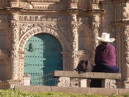
Peru is best known for its multitude of unique pre-Columbian cultures, first and foremost, of course, the Incas. The Incas, however, are only the shining crown of all the cultures that have gone before, which spread mainly along the coastal region and in the Andes all the way to the eastern mountain flanks towards the Amazon. Therefore, in the following we will provide an extra overview of the cultures of Peru. Today, Peru has almost 31.5 million inhabitants, with about a quarter of the people living in the capital Lima. There are officially three official languages in Peru: firstly "Spanish" as the language of the cities, secondly "Quechua" mainly in the highlands, thirdly "Aymara" in the area of Lake Titicaca. In addition, a large number of languages have survived in the lowlands to this day, albeit without official recognition. Not to be forgotten is Peruvian cuisine, which has developed into a true gourmet cuisine in many places over the last 20 years. Thanks to the fertile soil and cultural diversity, Peru has a very varied cuisine and almost every town boasts a regional speciality. The almost inexhaustible culinary offer results from rich natural resources and the different cultures that have shared a territory over centuries. The cuisine of Lima, the North Coast, the Amazon, Arequipa, the Andes as well as the modern so-called cuisine of Novoandina are all waiting to be discovered.
Capital Lima:
Lima's old city centre is located 12 degrees south of the equator at an altitude of 150 metres above sea level and about 10 kilometres from the Pacific Ocean. This makes it actually a tropical city, but the cold Humboldt Sea Current coming from the south in the Pacific ensures a temperate climate without rainfall. The surrounding area of Lima is desert, and during the so-called winter months from April to November, Peru's capital is often covered in dense fog, called "garua". Temperatures then can be quite fresh, averaging 13 degrees Celsius, while in the sunnier summer months they average 25 degrees Celsius. There is always high humidity. The city spreads over an area of more than 2,672 square kilometres. Since it is bordered by the Pacific Ocean in the west, it grows uncontrollably into the northern and southern desert as well as up the parched mountain hills. In 1535, Lima was founded as the Spanish "Ciudad de los Reyes" (= City of Kings) because of its natural harbour, and as early as 1544 it became the seat of the Viceroyalty and the Spanish Viceroys of Peru. In its history, Lima was repeatedly hit by strong earthquakes. In 1746, only 20 of the approximately 4,000 houses are said to have withstood, and of the 60,000 inhabitants, there were over 4,000 fatalities. But each time, the city was rebuilt even more magnificently, and so most of Lima's historic buildings were built after 1746. By 1919, the population had risen to 173,000, and it was a time of economic boom as well as a construction phase of magnificent buildings. In 1970, another earthquake shook the foundations of the badly battered city. In 1991, UNESCO declared the old city centre of Lima a "Cultural Heritage of Humanity", which resulted in financial aid for the renovation of squares and buildings as well as the creation of pedestrian zones. In 1996, the "Plaza de Armas" was spruced up and the surrounding historic buildings were given a fresh coat of paint. In 1997, the "Plaza San Martín" followed with a new attractive redesign.
Absolutely worth seeing:
- A tour of the old town, which has been restored with UNESCO funding, is a must. The main square, Plaza Mayor, is home to stately buildings such as the Palacio del Gobierno - seat of the government, the Municipalidad - Lima's city hall, Palacio del Arzobispo - archbishop's palace, the city cathedral with the Iglesia del Sagrario attached on the left. There is always something going on in this square; shortly before noon, you can often witness the changing of the guard of honour at the government building.
- Not far from the main square stands the Iglesia San Francisco with its attached monastery complex, which is also a UNESCO World Heritage Site. The monastery is famous for its countless historical records and for its catacombs. In 1950, the underground passages beneath the church, which lead into catacombs that are over 300 years old, were opened to the public. Until 1808, over 25,000 dead were buried in them.
- The most beautiful 18th century secular building in Lima is the private palace of the Marquis de Torre Tagle.
- The equestrian statue of the independence fighter José de San Martín stands on the Plaza San Martín. Turn-of-the-century houses with beautiful arcades line the square, and the venerable Hotel Bolivar from 1924, where you can have a cocktail or lunch, is striking.
- In terms of tradition, the Miraflores district is an old, middle-class neighbourhood that became a centre of business and modernity with chain restaurants, hotels, etc. in the 70-80s of the last century. Here you can live well and safely as well as take a nice walk on the cliffs above the Pacific.
- A visit to the capital Lima is worthwhile for the up-and-coming gastronomy alone. Nowhere else in the country are there such excellent restaurants in such variety.
- The pyramid-shaped temple of Huaca Pucllana is located in the heart of Miraflores and is now somewhat incongruously surrounded by modern buildings. Built of mud and clay - a building material that would not have survived more than 1,000 years in any other climate - the pyramid consists of seven staggered levels.
- South of the centre in Pueblo Libre is the Rafael Larco Herrera Museum, better known as the Larco Museum. The Larco Museum houses a huge collection of more than 40,000 Peruvian ceramics, much of which comes from the Moche and Chimú cultures. An excellent collection of goldwork, along with some textiles, stone carvings and metalwork also make a visit to the Larco Museum worthwhile.
- The Museo Nacional de Arqueología, Antropología, e Historia is dedicated to the study of Peru's history from prehistory to colonial times. The variety is impressive with ceramics, figurative stone carvings, obelisks, wrapped mummies, tombs, jewellery, tapestries, gold and metalwork, many with scale models of the archaeological sites.
- The Museo Oro del Perú is located in the Monterrico/Surco district and contains an incredible number of exhibits made of gold, silver, bronze, copper and other finds from Peru's past cultures.
- South of Miraflores is the suburb of Barranco, which has some beautiful architectural elements from the 19th and early 20th centuries and has long been popular with artists and writers.
- An excursion by speedboat takes you to the island of Palomino in the nature reserve of the Guanera Islands. A large sea lion colony can be observed and you can swim together with the friendly animals.
Peru's coast - the Costa:
The coastal area takes up only about 10% of Peru's land area, but about 50% of the population lives here and a quarter of that in Lima alone. The coast is a narrow, desert-like coastal strip on the Pacific Ocean. The maximum width in the north is about 150 km, in the south only 30 km. The maximum elevations of the coastal cordillera reach up to 1,500 metres. More than 50 rivers cut through the desert, but only 10 of them have water all year round. There are about 30 artificially irrigated river oases. Rainfall is less than 50 mm annually. The coastal desert is less characterised by shimmering heat, more by fog, the so-called garúa, and fine drizzle. Responsible for the Garuá is the Humboldt Current, a cold ocean current that flows along the coast from south to north. The average temperature of the water is only 10-14 degrees Celsius. The cold Pacific is rich in plankton, which in turn serves as food for seabirds and marine mammals. The warm Pacific air is thus cooled and condenses into fog. Humidity is around 80%. More and more irrigated areas are turning the coastline into farmland by diverting the Andean rivers and building large tunnels. A special feature are the lomas, the low coastal cordilleras of about 200-700 m.a.s.l., which are home to plants that can live solely on the humidity of the coastal fog, such as cacti, hardleaf shrubs and tillandsias. The average temperature in summer is 24 degrees Celsius, in winter 17 degrees Celsius, at night it drops to 4-7 degrees Celsius.
Absolutely worth seeing:
- Chiclayo is located in northwestern Peru and is the capital of the Lambayeque region. The city is a good starting point for sightseeing in the surrounding area. The Museo de Sitio Huaca Rajada as well as the Royal Tombs of Sipan Museum provide information about the discovery of the first three tombs discovered by Peruvian archaeologists at the Sipán site since 1987, known as the Lord of Sipán, the Old Lord of Sipán and the Spider Man. Another excursion leads to the Sican Museum, the Bosque de Pomac and to Túcume to the Huaca las Balsas pyramid.
- Trujillo (a day's drive north of Lima) is a splendid colonial city with a UNESCO World Heritage Site old town centre worth seeing. Outside Trujillo is the small fishing village of Huanchaco, where the fishermen go out to sea to fish on their traditional reed boats, the so-called Caballitos de Totora.
- Near Trujillo is the world's largest adobe city, Chan Chan - a UNESCO World Heritage Site. It was the former capital of the Chimú Empire.
- Not far from Trujillo, too, the sun and moon temples of the Moche rise as two huge mud-brick pyramids in the desert.
- The Sechin complex near Casma (about 370 km north of Lima) was built between 3,200-3,400 BC and is thus considered the oldest city in South America. The bas-reliefs in the rocks tell of a warlike brutal culture.
- From Lima, you can take an impressive train ride on the Ferrocarril Andino from Lima to Huancayo. The train ride follows a 346 km long track over the Western Cordillera into the Andean highlands and is accompanied by dreamlike passing landscapes. The highest station on the line is La Galera at 4,781 metres above sea level.
- Paracas is a small sleepy coastal town on the southern coast of Lima. Here you will find the Islas Ballestas, often referred to as the "little Galápagos Islands". The abundance of birds and the huge sea lion colonies can be marvelled at on a boat tour.
- Near Ica (approx. 300 km south of Lima) you will find the desert oasis Huacachina at the lagoon of the same name. Huge sand dunes spread out around the desert oasis and can be experienced by jeep, on foot or by sandboard.
- On a tour from Ica to the lonely Cañon de los Perdidos, you are guaranteed not to meet many other visitors.
- An excursion for wine lovers from Ica leads to various wineries in the region where excellent wines are produced, e.g. Viña Queirolo, Viña Vista Alegre, Viña Tacama.
- South of Ica lies the Nasca plain with the mysterious Nasca lines. A flight over the barren desert is the best way to recognise the shaded images. The nearby Chauchillo cemetery provides information about earlier burial rites in the region and is also worth a visit.
- Those who want to enjoy beach life in Peru do not have too much choice. North of Piura lies the former fishing village of Mancora, which has developed into a pretty seaside resort and leaves nothing to be desired. Bathing, surfing, relaxing, eating delicious food - holiday feeling is the order of the day here.
The Andean highlands - the Sierra:
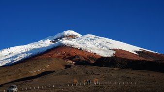
The Andean region covers about 30% of the country's surface and about 40% of the population lives in the valleys of the Sierra. In Peru, the Andes are divided into two mountain ranges: the Western and the Eastern Cordillera with high valleys at 3,500-4,000 m.a.s.l. Peru's highest mountain - the Huascarán at 6,768 m.a.s.l. - is embedded in the Western Cordillera as part of the so-called White Cordillera. The White Cordillera is also home to the largest glaciers in the tropics. Many volcanoes are also found here, and this is what is known as the fire belt of South America in the direction of Chile. In Peru, twelve of all volcanoes are still considered active. Some are over 6,000 metres high. Due to the deep-sea trench and plate tectonics, Peru is one of the most earthquake-prone areas on earth. The climate in the highlands is characterised by strong day and night variations, the sun is very intense and the nights are clear and cold. Here the rainy season is from November to March, dry season is from April to October.
Absolutely worth seeing:
- Cuzco, the former Inca capital, is still a magnet for visitors today, attracting people from all over the world. The history of the Incas, the colonial era, the many colourful festivals and Cuzco as a starting point to several important Inca archaeological sites make the city attractive. The archaeological site of Sacsayhuaman, located above Cuzco, is impressive with its huge stone blocks.
- From Cuzco, Peru's most famous sight, Machu Picchu, can be reached in various ways. The most comfortable way is certainly by train and bus as a 1- or 2-day tour. If you like hiking, you can reach Machu Picchu on the 4-day or the short (from kilometre 104) Inca Trail or on the alternative 4-5-day Salkantay Trail. Both routes are magnificent in terms of scenery.
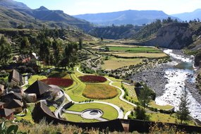
- The Sacred Valley of the Incas is full of attractions. Inca ruins such as Ollantaytambo and Pisac lie in overwhelming scenery, markets in the small villages invite you to browse, the weaving cooperatives of Chinchero explain the dyeing and weaving of the wonderful textiles, the salt terraces of Maras can be discovered on foot or by mountain bike. Adventure tourism also awaits in the Valle Sagrado, so you can go rafting on the Rio Urubamba or go horseback riding and hiking.
- There are many excursion options from Cuzco. A currently popular day tour leads to the so-called rainbow mountain Vinicunca.
- On the Altiplano in southern Peru lies Lake Titicaca with the islands of Amantani and Taquile, which are well worth a visit. From Puno, you can also reach the floating reed islands of the Uros on the lake and the tomb towers of Sillustani.
- The colonial city of Arequipa is situated at a pleasant altitude and exudes a beautiful ambience. It lies below volcanoes, has a pleasant climate all year round and the best museums and shops.
- The majestic Colca Canyon is easy to reach from Arequipa. It is famous for the condors that rise every morning at the so-called Cruz del Condor. But the entire canyon, which the Rio Colca has cut into the valley, is worth the journey. Original Andean villages, beautiful traditional costumes, steaming thermal baths, fantastic accommodation, hiking and mountain biking opportunities and all this in a majestic landscape below snow-capped mountains and volcanoes.
- A day's drive away brings you to a vast mountain landscape around Huaraz. To the south rises the Cordillera Huayhuash and to the north the Cordillera Blanca with Peru's highest mountain, the Huascarán at 6,768 m.a.s.l. This region is a dream for hiking, mountain climbing and multi-day treks. Snow-capped mountain peaks, turquoise blue lagoons, lush green plains with a variety of endemic plants and a friendly population await the visitor. Particularly worth mentioning is the Puya Raimondii, the largest pineapple plant in the world with a height of up to twelve metres. The excavation site at Chavín de Huantar is also worthwhile.
- Cajamarca is a beautiful colonial city with magnificent churches and numerous cultural centres at an altitude of 2,750 metres. The Inca king Patchacuteq had the thermal springs Baños del Incaer built here, where you can take a wonderful bath today. Cajamarca is historically very important because it was the residence of the Inca king Atahualpa, who was then captured and finally executed here in 1532 by the Spanish conqueror Francisco Pizarro. From the Cerro Santa Apolonia viewpoint, you can enjoy a magnificent view of the city and the surrounding area. Just outside are the stone tombs of Otuzco and the rock formations of Cumbemayo.
Amazon lowlands - the Selva:
The Amazon lowlands cover 60% of Peru's land area. However, only about 10% of the people live here, and there are 48 different ethnic Indian groups. In the Selva it rains on 222 days on average and about 2,960 mm per year. The average temperature is 24-28 degrees Celsius, lush tropical vegetation characterises the Peruvian lowlands. The Selva is the least developed area in Peru. The eastern slopes of the Andes down to the lowlands are called Montana and Yungas.
Absolutely worth seeing:
- Chachapoyas has nothing to do with lowlands and rainforest, yet it is the capital of the Amazon region in northern Peru. It is an ancient place, founded by the Spanish as early as 1538. The city is named after the Chachapoya, a prehistoric Andean people who got their name from the Incas. In Quechua, Chachapoya means "cloud people" or "mist warriors".
- The town is the starting point for the large fortress of the Chachapoya Kuelap, which is enthroned on a mountain saddle in the midst of fantastic scenery. The village of Karajia is also easy to reach and is home to another burial site of the Chachapoya culture. On a rock face, halfway up, several sarcophagi can be seen, in which presumably Chachapoya princes were buried.
- At 771 metres high, the Gocta Waterfall is the third highest waterfall on earth and scenically it is one of the most beautiful attractions in northern Peru. Day trips and hikes to the waterfall can be made from Chachapoyas.
- Leymebamba is a small town in the north-eastern Peruvian Andes, easy to reach from Chachapoyas and starting point for various excursions. The local archaeological museum is worth a visit and provides a good introduction to the region. One of the excursions leads to the tombs of Revash, another to the Laguna de los Condores, where several mummies of the Chachapoyas culture have been found.
- Moyobamba is located on the Rio Mayo on the way from Chachapoyas to Tarapoto. Here you can take beautiful boat trips to the Tingana Nature Reserve to meet local people, visit the orchid and hummingbird garden or take a bath in the sulphur baths.
- Tarapoto is a good starting point to get to a nearby jungle lodge. Peruvian rainforest, waterfalls, animal observations, medicinal plants, hikes, boat trips are on the programme.
- The Amazon metropolis of Iquitos can only be reached by plane or boat. The city itself is a mixture of past glories, exotic markets and jungle hole - and it is the starting point for tours in the Amazon. These range from day trips to stays of several days in remote jungle lodges.
- A visit to a jungle lodge in the Tambopata National Reserve in the Amazon region gives a wonderful impression of the rainforest. The starting point for lodges and tours is Puerto Maldonado, which is served by flights from Lima or Cuzco. Particularly attractive are the so-called collpas - salt licks where hundreds of parrots and macaws can be observed at dusk as well as at dawn.
- Even more remote is the Manú National Park in the headwaters of the Amazon and UNESCO World Heritage Site with over 18,000 square kilometres. The entire territory of the reserve stretches from the lowlands in the rainforest, where, in addition to a rich flora and fauna, a wide variety of Indian tribes can be found, up into the Andes. The region of Manú National Park is considered the richest in birds on earth and generally a paradise of bio-diversity. The Manú National Park can be reached either by land from Cuzco or by plane to Puerto Maldonado and from there by a day trip by boat.
Overview of the cultures of Peru:
Early history:
Around 40,000 to a maximum of 10,000 B.C., there were three immigration surges of people from Asia across the then dry Bering Strait to the American continent. Cave paintings dating back about 10,000 years have been found in the headwaters of the RIO MARANON in the Andes and at TACNA in southern Peru. Around 6,000 B.C., agriculture began with beans, cotton and pumpkins. From 3,500 BC, the cultivation of maize, peanuts, potatoes and quinoa (= Andean millet) began. From 3,000 B.C. the domestication of llamas and alpacas began in the area of the COLCA CANONS and the WHITE CORDILLERE in the Andean highlands.
Kotosh (1,850 - 1,200 Y.B.C.):
Settlement from the lowlands in the area of HUANUCO north of Lima with development of a maize culture and production of ceramic vessels with bow handles. Also known for the "Temple of the Crossed Hands" - one of the earliest testimonies of sculptural creation in Peru.
Sechín (1.800 - 500 J.B.C.):
Complex of ruins with terraces, ceremonial plazas and a cult centre extending over 1.5 km near CASMA on the north coast of Peru.
Chavín (1,000 - 200 J.B.C. - very fluctuating data):
Considered the mother culture of Peru and named after the main site of CHAVÍN DE HUANTAR in the WHITE CORDILLERE. There, temple and fortress remains were found, decorated with beautiful low-relief stone work. Typical ceramic finds in grey, black, red and brown are carafe-like vessels with negative paintings. Characteristic motifs are predatory cats, birds, snakes and caimans. The most famous finds of that time are the TELLO-OBELISK and the RAIMONDII-STELE with impressive reliefs (Puma man >>> power of the holy puma for man).
Pucará (ca. 600 A.D.):
PUCARÁ was a regional centre of a pottery-making community over several cultural successions near SILLUSTANI on Lake Titicaca. Only after 1940 was the main structure uncovered - a semicircular temple or palace built of house stones.
Finds: block-like stone statues, red-primed pottery with yellow and black patterns. An impressive stele of a "lurch-fish-snake creature" was recovered from the tomb of the temple pyramid. The main motif of this culture was a kind of "angel with sceptre", whereby archaeologists suspect that this representation could refer to the predatory cat of CHAVÍN. Furthermore, similarities with the fertility god at the Sun Gate of TIWANAKU as well as the creator god of the WARI and later the INKAS can be seen. >>> This, in turn, is interpreted as a lead object for the proof of widespread cultural transparency in ancient Peru.
Paracas (700 J.B.C. - 200 J.A.D.):
On the desert-like Paracas Peninsula, the archaeologist JULIO C. TELLO excavated a burial site with 429 mummies in 1927!!! The exclusively male mummies were wrapped in countless finely woven colourful cloths and garments bearing representations of daily life. The weaving technique as well as the colour composition of the fabrics are considered unique in the world! The threads were sometimes spun so thinly and woven so finely that one counts up to 200 threads per square centimetre! Our modern looms manage 60 threads per square centimetre!
The PARACAS culture is divided into 3 periods, which are distinguished by the type of burial:
1,000-700 Y.B.C. - Early PARACAS:
-Single mummy bundles in single graves.
- Mummies in elongated form, wrapped in reed bundles and tied.
- Towards the end of this period, transition to mummy bundles in squatting position.
700-200 Y.B.C. - Middle PARACAS:
- PARACAS caverns = underground shaft tombs, which were very elaborately designed with up to 12 mummies. The mummies were tied in a bundle in a squatting position with the help of cloth (= FARDO FUNERARIO).
- They were buried together with many grave goods such as clay pots with food and drink, jewellery, weapons and other precious objects.
- Some mummies were also in large clay pots.
300 Y.B.C.-200 Y.A.D. - Late PARACAS:
- PARACAS necropolis = mass graves with several dozen mummies in a large burial cave.
- The so famous PARACAS fabrics, called MANTOS, originate from this period. Up to 150 fabrics were used per mummy, depending on the social status of the deceased.
- Often, articles of clothing for daily use were also added to underline the rank of the deceased, such as special turbans or feather garments.
There are no remains of dwellings or the like, and it is assumed that PARACAS was a special cemetery for high dignitaries. This is also supported by skull deformations and skull trepanations.
Nazca (100 - 600 y.o.c.):
The NASCA culture is often described as a continuation of the PARACAS culture. In fact, NASCA also found many dead bodies wrapped in cloth, trophy heads and very colourful, splendidly painted pottery. Vases were decorated with up to eight different colours with geometric shapes as well as animal motifs. Because of the very similar animal motifs, the mysterious desert paintings in the "Pampa de Nasca" are attributed to the NASCA culture. No ruins of any kind have survived. Researchers see the reason for the demise of this empire in a great deluge. The coastal valleys are said to have been flooded by very heavy rainfall in the Andes and the habitat of the people destroyed.
Moche / Mochica (200 - 800 A.D.):
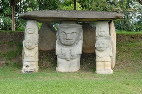
The cultural centre of the MOCHE or MOCHICA culture was on the coast in northern Peru. Remains of the moon pyramid and the sun pyramid made of adobe bricks are still preserved. The MOCHE are often called the Greeks of South America. They were warlike, but left behind extremely refined art: - masters of irrigation, - wall paintings, - wood, shell and textile work, excellent workmanship of gold and copper. They produced the most imaginative pottery! The life of the MOCHE can indeed be traced in their pottery, for there is no scene of life that the MOCHE did not mould in clay: clothing, food, handicrafts, war, procreation, birth, sickness, the cult of the dead, demons, and so on. Each vessel was painted in white and reddish brown in a very fine and detailed way. In 1988, the Peruvian archaeologist "Walter Alva" made a spectacular find of the MOCHE culture: He found the tombs of the so-called "Ruler of SIPÁN" and a little later of the "Old Ruler of SIPÁN", the "Spider Man".
Tiwanaku / Tiahuanaco (100 J.B.C. - 1,000 J.A.D.):
This culture peeled out of the PUCARA tradition around 100 Y.B.C. and developed into the second great ancient Peruvian empire (after CHAVÍN). Its centre and origin was the strong spiritual and religious power of Lake Titicaca, where a ceremonial centre with the Sun Gate was created around the creator deity VIRACOCHA. Finds of the TIWANAKU culture testify to its widespread distribution throughout the central Andes region as well as along the coast. The spread of the beliefs took place peacefully, without completely eradicating the beliefs of the traditional local religions. One speaks of the first great empire in South America! The headquarters and starting point of the spread was the ruined complex of TIAHUANACO, today located in Bolivia, 21 km from Lake Titicaca on the Altiplano. The most famous legacies are the Sun Gate, stone stelae and huge stone blocks weighing several tonnes and precisely worked to build their temple complexes. Two sophisticated water systems once criss-crossed the temple city, and they developed an ingenious form of agriculture for the Andean highlands. Particularly noteworthy is the frequent depiction of puma and condor, also as puma man and condor man in stone as well as ceramic works.
KEROS - ceramic drinking cups - are typical of the TIWANAKU culture. The supreme deity of this religious and political centre was VIRACOCHA, the creator god, fertility god, rain god. He was figuratively represented throughout the empire on textiles, pottery, gold jewellery, stone... The decline of this first real Andean empire is the subject of many different theories, none of which can be regarded as proven. (Within Peru, TIWANAKU is often placed in the shadow of WARI, as WARI is located on today's Peruvian territory and TIWANAKU on Bolivian territory...).
Huari / Wari (600 - 800 A.D.):
Around 600 A.D. a second main centre developed next to TIWANAKU in HUARI near AYACUCHO in Peru. HUARI was a temple and city settlement where once about 20,000 people might have lived. The stelae, the stone nail heads, the stone blocks weighing tons, fabrics, pottery and jewellery have the same features as TIWANAKU. The belief was also adopted, and it was carried on within HUARI's sphere of influence, even by military means. The MITMAC system was introduced, i.e. the forced relocation of peasants to different areas, thus spreading the culture.
Around 800 A.D. the HUARI culture had another centre with the ceremonial centre PACHACAMAC (= world creator) near Lima. Later, the area was also incorporated into the NASCA culture. Since HUARI culture was largely identical to TIWANAKU culture in terms of both style and content, HUARI art was often called desert TIWANACU. In terms of political organisation, however, there was no connection, and both cultures remained autonomous in this respect!
Chincha (1,000 - 1,450 A.D.):
They were considered a warlike people who were eventually defeated by the Inca army, but never adopted their religion. The CHINCHA kingdom was located on the coast near ICA, PISCO and NASCA. They were traders and seafarers and specialised in the exploitation of the much sought-after and precious spondylus shell (= spiny oyster) in the coastal waters of Ecuador. There was an elaborate irrigation system, fine fabrics and many pottery finds. No ruins have been found, as the structures were probably made of adobe bricks.
Chimu (1,000 - 1,450 A.D.):
The CHIMU culture developed on the north coast of Peru in the area of the former MOCHE culture. The so-called SiCÁN culture is regarded as a transitional culture. The progenitor and first king was NAYMLAP, who is said to have come from the north across the sea on a beam raft and founded the CHIMU empire with the great adobe city of CHAN-CHAN. CHAN-CHAN spread over an area of more than 18 km², probably had more than 100,000 inhabitants and is considered the largest city of adobe! Their religion and art were entirely based on their life in the desert and by the sea. Their wall friezes as well as the black polished pottery mostly depict sea birds, fish and wavy lines. The religion was influenced by the cult of the moon, and there were moon pyramids. It was believed that the moon brought moisture to the earth, while the sun dried everything out... Moreover, the moon could cover the sun's disk - solar eclipse. Worship of lunar animals such as the dog, wolf and fox.
They had developed an excellent irrigation system, but this was ultimately their undoing when the INKA captured them. They cut off the water supply to the capital CHAN-CHAN and were thus able to conquer the large CHIMU empire of 1,200 km in length in the coastal area without bloodshed! Astonishing gold treasures have been found from the CHIMU culture, and it is assumed that many precious objects still lie dormant in the desert soil. They were masters in driving techniques, in chasing, in breakthrough work, and they knew casting in the lost mould. Gold masks, gold chains, gold crowns etc. were often decorated with turquoise, it was the sacred stone of the CHIMU.
Inca (1,200 - 1,572 A.D. / = death of the last Inca ruler):
The INKA were a dynasty of rulers in the central Andes region who, before the invasion of the Spaniards, ruled an enormous empire with their capital CUSCO, which included the present-day states of Ecuador, Peru, Bolivia, as well as parts of Argentina and Chile!
The actual INKA were more or less just a ruling noble family whose supreme emperor was the SAPA INCA. He was considered a demigod, as he was directly descended from the sun INTI, the supreme deity of the INKA. Their special ability to build up their huge empire consisted, on the one hand, in their tight and controlled organisation and, on the other hand, in the fact that they did not destroy the conquered cultural peoples, but made use of their respective specific abilities. For this reason, at the beginning of archaeological research in South America, it was believed that all highly developed cultural property could be attributed to the INKAS. However, this is wrong! On the contrary, one could say that the INKA empire represents the culmination of centuries of development of the most diverse cultures in the central Andean region.
The INKA were "pre-modelled" by two great cultures:
1. TIAHUANACO with its mythology, monumental architecture as well as MITMAC, the system of forced resettlement of peasant families.
2. HUARI with its centrally controlled political organisation, military campaigns and logistics, the construction of cities as a symbol of power, the trapezoidal shape as a stylistic element of architecture and possibly even the knot script.
Below is an overview of special features and achievements within the INKA empire:
- Without knowing the wheel, the INKA built mighty temples and dwellings of stones weighing tons on mountain ridges and slopes. The stone blocks were worked so precisely - without knowledge of iron - with stone hammers made of hematite or meteorite rock that they fitted together without joints. Stone pegs and grooves and no mortar at all make the walls earthquake-proof! (Walls with a slight inward slope, predominantly the trapezoidal shape for windows and doors and niches).
- Huge terraces with excellent irrigation systems were built around the cities on steep slopes. Crop cultivation was at its peak and no one had to go hungry in the INKA Empire! Many of the terraces and water channels are still in use today!
- The social structure of the state was strictly structured and closely controlled. At the top there was the noble family around the SAPA INCA as well as the high nobility - recognisable by the golden ear plugs that only they were allowed to wear. This was followed by the priestly class with the high priest WILLAQ UMU. The kingdom, which was divided into four parts, was headed by an APU - a kind of prefect. And down to the last member of the family, the common people were also subdivided, always keeping to a division of 10 (decimal system). It was precisely divided at what age and gender-specifically what kind of work each citizen had to do, from when one was allowed to marry, and so on. In the course of life, every non-noble and INKA who did not belong to the priesthood was thus also called up to MIT'A for about 25 years.
- One could describe this MIT'A as a kind of "community levy in the form of a labour service". Depending on the type of work, it had to be performed over a longer or shorter period of time. For example, it was shorter in the mine than in agriculture or textiles. In this way, all craft, artistic and agricultural fields were covered for the "common good".
- The INKA, like all pre-colonial peoples/cultures, knew no writing. But they developed QUIPU for statistics and as a means of communication - a knotted script with the help of which digits and numbers could be transmitted accurately. Statistics were kept on the entire population belonging to the INKA empire (which was about 12 million people when the Spaniards arrived), on crop yields, labour services, etc. According to recent findings, QUIPU also contains word syllables, which can ultimately also express words and sentences. However, this is not yet 100% proven and has not yet been 100% decoded!
- The INKA were excellent road builders, their paved road network covered about 20,000 kilometres! The main Andean road was 5,200 km long and 6 metres wide, the coastal road was 4,000 km long and 8 metres wide! There were many connecting and secondary roads with bridges and stairs. On these paths and roads, relay runners were continuously on the move, so-called CHASQUIS, who carried important messages, news and statistics from all parts of the empire to the capital CUSCO or, conversely, orders from CUSCO everywhere. It is said that important messages could have been relayed in this way for up to 250 km a day!
- The supreme deity of the INKA was INTI - the sun. The SAPA INCA was considered a demigod, as he was a direct descendant of INTI. Thus, all festivals, ceremonies, offerings, etc. revolved around the stars, especially the sun! The main festival of the INKA was the INTI-RAYMI - the winter solstice.
- Festivals were celebrated with all the splendour of the INKA empire, and since gold was seen as "tears wept by the sun", this noble metal was used a lot for ornaments, jewellery, masks, etc. Gold was ultimately one of the downfalls of the INKA, as the Spaniards crushed their empire and their culture because of gold.
- The INKA knew no iron, no horse and no wheel. Their weapons of war and shields were far inferior to those of the Spanish. And lying was a severe punishment among the INCA!
Facts and figures of Peru:
Land area: 1,285,216 sq km
Population: Almost 31.5 million people, of whom 37% are mestizos. About 47% are considered indigenous, predominantly Quechua and Aymara speaking peoples. 15% are of European descent and four percent are estimated to be Afro-Peruvians. The remaining three per cent are of Asian descent, mainly Chinese and Japanese. Peru has the largest proportion of people of Chinese descent in all of Latin America.
Capital: Lima with almost 8.6 million inhabitants, the metropolitan area is home to almost 10.5 million people.
Highest mountain: Huascarán, 6,768 metres above sea level.
Form of government: presidential republic
History: According to many pre-Inca cultures, the Inca Empire dates back to about 1,200 A.D. The 11th Inca Huayna Capac was a successful war leader. Under him, the Inca Empire had its greatest expansion, covering around 1 million square kilometres. In 1527, a troop of Spanish conquerors under Franzisco Pizzaro reached the northern coast of Peru. Determined, they moved from the coast into the hinterland as far as Cajamarca. Perhaps the gold rush gave them the courage for a shabby ambush with which they captured Atahualpa and finally murdered him. The leaderless Inca nation was shattered, and on 18 January 1535 Pizzaro founded Lima as his new capital. Despite subsequent uprisings, the Inca empire was shattered and the Spanish were the new masters in the country. In 1821, Peru declared its independence, although this was only considered secure after several more victorious battles under Simon Bolivar and General Sucre in 1824. In 1825, Altperu in turn declared itself independent - Bolivia became an independent state. It was not until 1879 that Spain finally recognised Peru's independence. From 1879-1883, the bloody Saltpetre or Pacific War took place. In 1941/42 there were armed clashes between Peru and Ecuador over a border dispute in the Amazon, in which most of the disputed territory was awarded to Peru.
Economy: According to the World Bank, Peru belongs to the group of emerging countries in terms of economic indicators. The economy has grown by an average of 6.4 % over the last ten years. A distinction is made between traditional products such as mining, fishmeal, petroleum and agriculture and non-traditional products such as non-metallic ores, chemical products, mechanical engineering, steel and the textile industry. Peru's numerous indigenous population groups in particular still live in many cases from independent subsistence farming using traditional methods.
Currency: Peruvian sol
Language: Spanish, Quechua and Aymara
Festivals: In general, Peru celebrates often and exuberantly. Only a small selection can be given here. Mostly there are festivities with music parades, dances in traditional costumes, local markets and real folk festivals.
In Puno on Lake Titicaca, the patron saint is celebrated in the town of "Virgen de la Candelaria" with a large masked carnival at carnival time. The important festival has been recognised as an intangible cultural heritage by UNESCO.
During Semana Santa, Holy Week, Easter processions are held in many places. On Easter Monday, it is particularly attractive in Cusco when the statue of the earthquake saint, the so-called "Black Christ", is carried through the streets. In Ayacucho, too, there are several daily processions in typical costumes.
At the end of May/beginning of June, 60 days after Easter Sunday, Corpus Christi is celebrated throughout the country as one of the religious festivals, especially beautiful in Cuzco.
Every year at the end of May/beginning of June, the snow star festival Qoyllur R'iti is celebrated near Cuzco. This festival consists of a hike of several days to Mount Qullqipunku in the valley of Sinakara. Thousands make the pilgrimage with their families to the church of Sinakara.
Probably the most famous festival of the Incas is the Inti Raymi at the winter solstice in June. In Cuzco there are colourful parades and performances in historical costumes at the Sacsayhuaman fortress.
From 15 to 17 July, all hell breaks loose in Paucartambo when the Masked Carnival is on the festival programme.
Every year on 28 July, Lima celebrates Independence Day with concerts and events.
Reisen in Peru:
Einreisebedingung: Alle Reisedokumente müssen bei Einreise noch sechs Monate gültig sein. Sollte Ihr Pass nicht die erforderliche Gültigkeitsdauer enthalten, werden Sie an der Grenze (beziehungsweise am Flughafen) zurückgewiesen, auch wenn sie sich nur für einen kurzen Zeitraum in Peru aufhalten möchten. Deutsche Staatsangehörige benötigen für touristische Aufenthalte von bis zu 90 Tagen pro Halbjahr kein Visum. Bei der Einreise werden die Einreise- und Aufenthaltsdaten elektronisch von der peruanischen Grenzbehörde erfasst, dazu werden die Einreise und die bewilligte Aufenthaltsdauer im Reisepass vermerkt.
Impfungen: Bei direkter Einreise aus Deutschland sind keine Pflichtimpfungen vorgeschrieben. Eine Gelbfieberimpfung ist für alle Personen ab einem Alter von neun Monaten empfohlen, die in Gebiete unterhalb von 2.300 Metern in folgenden Regionen reisen. In Gebieten oberhalb von 2.300 Metern inklusive der Stadt Cusco, Lima, Machu Picchu und dem Inka Trail ist keine Gelbfieberimpfung empfohlen. Aus Peru kommend kann der Nachweis der Impfung bei Weiterreise in ein Drittland verlangt werden.
Klima/Reisezeit: Das Klima in Peru teilt sich in drei verschiedene Klimazonen. Der Humboldtstrom sorgt für das heiße und trockene Wüstenklima an der Westküste Perus. Im südamerikanischen Sommer von Dezember bis März herrschen dort angenehme 25 Grad Celsius. Im Winter von Juni bis September herrscht dort oft dichter Nebel, der als Garúa bezeichnet wird. Der Küstenstreifen von Lima bis zur Grenze von Ecuador hat ein etwas feuchteres Klima als der wüstenartige Streifen von Lima bis Chile. Dort variieren die Temperaturen von 15 Grad Celsius im Winter bis zu 35 Grad Celsius im Sommer. Im Andenhochland herrscht von April bis Oktober Trockenzeit. Die Tagestemperaturen überschreiten nur selten die 20 Grad-Marke, nachts kann es sogar Frost geben. Durch die trockene und klare Luft entsteht eine fantastische Weitsicht. In der Regenzeit von November bis März fallen heftige Niederschläge. Je höher man in das Gebirge vordringt, desto kälter wird es. Die Jahresdurchschnittstemperatur in 3.000 Meter Höhe liegt bei 16 Grad Celsius. Das Tiefland ist ganzjährig feuchtschwül mit ergiebigen Regenfällen. Die perfekte Reisezeit ist in Peru eindeutig abhängig vom konkreten Reiseziel sowie den persönlichen Vorlieben und Aktivitäten. Für einen Badeurlaub an der Pazifikküste sind die Sommermonate geeignet, also Dezember bis März, wenn die Temperaturen meist um 29 Grad am Tage und 20 Grad in der Nacht liegen. Von Mai bis Oktober ist die beste Reisezeit in Peru, um das Hochland der Anden und damit auch Machu Picchu zu besuchen. Allerdings sollte man daran denken, dass im Hochland die Temperaturen nur bei etwa 20 Grad liegen und die Nächte frostig werden können. Im peruanischen Regenwald liegen die Temperaturen ganzjährig je nach Höhenlage zwischen 20 und 35 Grad Celsius. Wie im Regenwald üblich kommt es in dem dauerhaft feuchtheißen Klima häufig zu ergiebigen Regenfällen.
Ortszeit: Die Zeitverschiebung beträgt nach Mitteleuropäischer Zeit (MEZ) minus 6 Stunden, während der europäischen Sommerzeit beträgt der Zeitunterschied minus 7 Stunden.
Addresses:
Embassy of the Republic of Peru
Taubenstr. 20, 4. Etage
10117 Berlin
Tel: 030 20 64 10 3
Fax: 030 20 64 10 77
info@embaperu.de
http://www.botschaft-peru.de