
Travelling in Bolivia: always a touch of adventure - INTI Tours
A treasure chest full of surprises
On our tours in Bolivia you will experience La Paz, Lake Titicaca, ancient Inca trails, the Yungas and the Salar de Uyuni with its fascinating lagoons.
Bolivia - the country is often called the "beggar on the golden throne". Why? Because it is the poorest country in South America with all the consequences for the local population as well as for the country's infrastructure. But this only explains half of the name, namely the "beggar". There is also the "golden throne". And this expression refers to the country's wealth of natural resources as well as its magnificent landscapes.
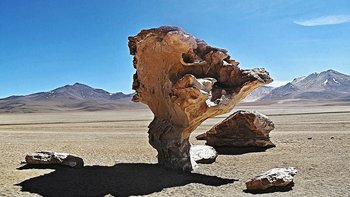
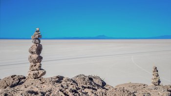
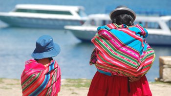
Bolivia can boast several superlatives: Lake Titicaca is the highest navigable lake in the world, La Paz with its seat of government has the greatest difference in altitude of any metropolis, the Salar de Uyuni with its almost 12,000 square kilometres is the largest salt pan on earth and thus also the largest known lithium deposit in the world. The life of the indigenous people in Bolivia is very authentic, the markets are colourful and lively, the routes promise adventure and the natural regions are fantastic and in many places almost untouched.
Discover Bolivia and experience lively life as well as lonely natural regions from the snow-capped Andean peaks down to the Amazon basin. Enjoy an unforgettable time in the Andean country and contribute to the positive development of the tourism sector in Bolivia.
Welcome to Bolivia!
Country information Absolutely worth seeing Facts and figures Travel in Bolivia Addresses
Our types of travel in Bolivia
Examples of individual dream trips in Bolivia

Individual Bolivia Tour from the Jungle to the Andes
Experience the fascinating lowlands, the breathtaking Andean highlands around La Paz, the huge white salt lake of Uyuni and the fantastically coloured mountain lagoons on this individual Bolivia trip.
22 days Individualreise 1 up to 4 travellers
upon request

Individual Tour - Mountaineering in Bolivia
Bolivia, in the heart of South America, is considered a land of mountains. Vast untouched landscapes make the pulse of every scarur lover, hiker and mountaineer beat faster. From short hikes to expeditions lasting several days, everything is possible - here is a sample trip.
17 days Individualreise 1 up to 6 travellers
upon request
Individual travel in Bolivia and Chile
In just ten days, you will immerse yourself in a fantastically beautiful world and almost feel transported to another continent. You will not be able to escape the fascination of Bolivia and Chile.
10 days Rundreise 2 up to 6 travellers
upon request
You might also like this...
Peru Experience the Land of the Incas - Option I
The trip "The Land of the Incas - Varinate I" is suitable for those who visit Peru for the first time. It dives deep into the region of the Incas around Cuzco and the Sacred Valley.
12 days Bestseller 2 up to 12 travellers
upon request

Peru Experience the Land of the Incas - Option II
The trip "The Land of the Incas - Variant II" is suitable for those who visit Peru for the first time. Two days Machu Picchu lets you intensively experience this highlight of all Inca sites.
12 days Bestseller 2 up to 12 travellers
upon request

Country information on BOLIVIA: „In the heart of South America“
Today, Bolivia's national territory covers about 1.1 million square kilometres, which corresponds to about three times Germany. The total population currently numbers 11 million people. Thus, the country has the lowest population density in South America with about 1 inhabitant per square kilometre. About 80% of the total population lives in the higher parts of the country, i.e. in the Andean region. 57% of the people live in cities, and 43% in rural areas. Along with Paraguay, Bolivia is a landlocked country without access to the sea! Bolivia lost its share of the Pacific coast to Chile in the Saltpetre War (1879 - 1884).
Bolivia has two main geographical regions: The Andean highlands cross Bolivia in the southwest, while the lowlands characterise the north and east of Bolivia. Between the eastern and western cordilleras of the Andes stretches the Altiplano, one of the largest plateaus on earth! Its dimensions are 800 km long and 130 km wide, the altitude of the Altiplano is between 3,500 and 4,000 metres above sea level. The Cordillera Real, the most beautiful part of the Eastern Cordillera, reaches heights of over 6,000 metres in the area of Lake Titicaca and the city of La Paz. Bolivia and Peru share Lake Titicaca together. The entire mountain zone of the Western, Eastern Cordillera and Altiplano covers about a quarter of the country's surface. The transition zones between highlands and lowlands are the semitropical forested valleys and the Yungas. The Amazonian lowlands lie north of the Royal Cordillera and impress with their diverse flora and fauna. This forest zone, known as "llanos", lies at 100-300 metres above sea level and occupies most of Bolivia. This area includes subtropical hilly areas, endless savannahs, vast rainforests, hot semi-desert areas and water-rich rivers flowing towards the Amazon.
Capital Sucre and seat of government La Paz:
The capital of the Republic of Bolivia is the city of Sucre, the seat of government is in La Paz.
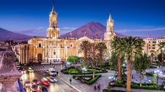
Today, Sucre has about 240,000 inhabitants. The city lies at 2,790 metres above sea level and has an average temperature of 12 to 24 °C. Sucre is the constitutional capital of Bolivia, but had to cede the seat of government to La Paz in 1899 and is generally somewhat remote from the country's events. Sucre was founded as a Spanish city in 1538 and quickly developed into one of the most important Spanish-vice-royal centres in South America. In 1552 Sucre became a bishop's see and in 1559 the seat of the royal court. Finally, in 1624, the royal-papal university was founded, which soon attracted scholars from all parts of South America. Sucre was once a political and intellectual focal point of South America. Around the central main square, one can still sense the once important times. Magnificent Renaissance, Baroque and Mestizo buildings, beautiful oriels, portals and courtyards tell of past grandeur and present beauty. About 11,000 students live in Sucre. In 1992, Sucre was declared a cultural heritage of humanity by UNESCO, thus receiving funds for the preservation of the city centre. The "Sucrens" call their city "Ciudad culta" - cultural city - or "Ciudad blanca" - white city. Today, almost 2 million people live in La Paz - including El Alto. Whites, criollos, mestizos, cholos and indigenous people meet daily in colourful, lively hustle and bustle, and despite all the modernity, market hustle and bustle, old indigenous beliefs, tradition and music predominate in La Paz. La Paz is the Andean capital of the Aymara indigenous people. Over the past 200 years, the population of La Paz has tripled, making it the largest city in Bolivia. La Paz is the highest major city on earth, with the greatest difference in altitude of any settlement! It stretches from 3,100 metres above sea level to almost 4,100 metres above sea level, and the highest civilian airport in the world is in "El Alto" at 4,088 metres above sea level. The colonial-era city centre of La Paz with its typical Spanish checkerboard street pattern lies about 500 metres below the edge of the plateau. Another 500 metres or so lower are the better parts of town with posh residential areas, embassies and consulates, public schools and clubs. The lower, the milder and warmer the climate, the more pleasant the life. This is why the upper town - "El Alto" - is home to the poor population, predominantly Aymara. While palm trees and tropical plants grow in the basin below, the thermometer in "El Alto" often drops below zero degrees at night! Behind La Paz rises the mighty "Illimani" mountain, 6,462 metres high and covered in snow and ice all year round. The general average temperature in the centre of La Paz is 11.2 degrees, the daily maximum temperature is 18 degrees on average.
Absolutely worth seeing:
Absolutely worth seeing Sucre:
- Sucre has 36 churches and 19 bell towers - it is nice to stroll through the old town centre. The market, the textile museum and the hat factory "Charcas" are worth a visit. In some restaurants, typical music is played in the evening.
- The main square forms the attractive city centre with the impressive Casa de la Libertad, where Bolivia's Declaration of Independence was signed and which now houses a museum about the Bolivian freedom movement. The same complex is also home to South America's second oldest university, dating from 1624, which today offers major courses in medicine, pharmacy and agriculture. Between the Casa de la Libertad and the cathedral stands the present-day city hall, which was Bolivia's government palace until the government moved to La Paz in 1899!
- One of the best viewpoints of Sucre is the easily accessible Plaze Anzures
- About 5 km from Sucre lies a sight that is a whopping 68 million years old. On a 1.2 km long sandstone wall, about 5,000 dinosaur footprints can be seen. At that time, today's rock face was a shallow beach in whose sand the footprints remained, fossilised and were lifted to their present position with the unfolding of the Andes. It is assumed that there are other traces hidden under the visible upper layer. The impressions from the Cretaceous period were discovered at the site of a cement company under several layers of sediment and form one of the largest collections of fossilised dinosaur tracks in the world.
- Tarabuco, 67 km from Sucre, is known for its Sunday market selling local textiles and agricultural products such as maize, potatoes and cereals. This is also where the big "Pujllay" festival takes place every third Sunday in March, in memory of a successful battle against the Spanish colonial army.
Absolutely worth seeing La Paz:
- La Paz is lively and full of indigenous life. A stroll through the streets and squares offers many things to observe and photograph: Plaza Murillo with the government building and the city cathedral, the narrow Calle Jaén with small museums and pubs, the lively Calle Sagárnaga with shopping opportunities in front of and inside the winding houses, the Mercado de las Brujas with a thoroughly bizarre range of goods (e.g. llama embryos for offerings), the Plaza San Francisco with the church of the same name.
- Mi Teleferico is the name of the new cable car network that connects La Paz with El Alto. A must for the fantastic view alone.
- Donnerstags und sonntags findet in El Alto ein riesengroßer Indigenen-Markt der Aymara statt.
- Richtung Mallasa liegt das bolivianische Valle de la Luna. Dieses sogenannte Mondtal besteht aus tausenden von Felsnadeln, Felsspalten, Erdhügeln und kraterähnlichen Formationen. Das Valle de la Luna wurde im Lauf von Millionen Jahren durch Erosion und Klimagegensätze gebildet. Starke Regenfälle und Temperaturschwankungen führen zur Abtragung des Lehmbodens und lässt die bizarren Gebilde entstehen.
- Ein Ausflug in die Palca-Schlucht mit den rot aufsteigenden Felswänden und Ausblicken auf den mächtigen Illimani ist absolut lohnenswert. Man kann hier auch gut wandern.
- Tagesausflug nach Tiwanaku – etwa 70 km von La Paz entfernt. Die prä-inkaische Ausgrabungsstätte ist UNESCO-Weltkulturerbe seit dem Jahr 2000. Tiwanaku wird von den meisten Archäologen als eine der wichtigsten Stätten in den Hochanden angesehen.
- Wer gerne Mountainbike fährt, kann ein aufregendes Mountainbike-Abenteuer auf der sogenannten "gefährlichsten Straße der Welt" von La Paz aus in die Yungas unternehmen.
Bolivianisches Hochland:
Das Hochgebirge der Anden teilt sich nördlich von Bolivien im südlichen Peru in zwei Ketten: in die Ostkordillere und in die Westkordillere.
Die Westkordillere längs der Grenze zu Chile ist vulkanischen Ursprungs und enthält unter anderem auch radioaktive Minerale. Sie erstreckt sich vom Titicacasee südwärts bis an die Grenze von Argentinien und hat eine Durchschnittshöhe von 5.000 Metern. Hier liegt auch der höchste Berg Boliviens – der 6.520 hohe Sajama. Insbesondere im Süden dieser Andenkette ist die Landschaft trocken, unfruchtbar und trostlos. Das Klima der dort vorherrschenden Trockenpuna oder Tundra gehört zu den unwirtlichsten der Welt mit täglichen Temperaturunterschieden bis zu 60°C! Von +25°C am Mittag bis zu -35°C bei Nacht! Man spricht auch von einem "andinen Sibirien, das nicht einmal den kurzen blühenden Frühling der asiatischen Tundra kennt".
Bei der östlich des Altiplano gelegenen Ostkordillere handelt es sich wie bei den Alpen um ein Faltengebirge, dessen Kennzeichen Granitstöcke und Schieferplatten sind. Gewaltige schneebedeckte Gipfel (z.B. der Illimanimit 6.462 M.ü.M. und der Illampú mit 6.424M.ü.M. geben dieser Kordillere ein majestätisches Aussehen. Die Ostkordillere ist geleichzeitig eine große natürliche klimatische Barriere für die feuchten Winde aus dem östlichen Tiefland und so mitverantwortlich für das trockene Klima des Altiplano. In der östlichen Kordillere liegen die wesentlichen mineralischen Schätze Boliviens!
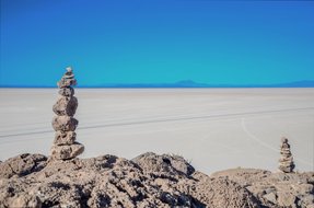
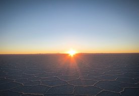
Zwischen den beiden Kordilleren liegt das Hochplateau des Altiplano mit einer durchschnittlichen Höhe von 3.800 M.ü.M. und einer Gesamtfläche von rund 200.000km². Das Altiplano verdankt seine Entstehung den Gletscherablagerungen der beiden Kordilleren. Das größte und wichtigste Becken des Altiplano ist das des Titicacasees. Mit seiner riesigen Wasseroberfläche (8.300 – 8.900km² - schwankende Angaben) und einer mittleren Wassertemperatur von 12°C mildert er das sonst kalte und trockene Klima des Hochplateaus in seinem nördlichen Abschnitt. Durch das harte Klima ist das Leben auf dem Altiplano nie einfach gewesen. "Das geizige Land" – wie ein bolivianischer Dichter die Puna der Hochebene genannt hat – diente schon in uralten Zeiten als Weideland für die südamerikanischen Kameloide – die Lamas, Alpakas und das wilde Vicuna. Mit den Hochkulturen, insbesondere Tiwanaku, begann der systematische Anbau von Kartoffeln, Andenhirse und an den Ufern des Titicacasees Mais sowie Saubohnen. Auch heute noch ist der Titicacasee ein bedeutendes landwirtschaftliches Gebiet und in seinem nördlichen Teil dicht besiedelt. Der südliche Teil der Hochebene besteht im Wesentlichen aus Salzwüsten, in deren Mitte der Salar de Uyuni liegt – mit um die 12.000 qkm größter Salzsee der Erde und dessen Wasser von einer dicken Salzschicht bedeckt ist. Das Klima hier ist extrem kalt und trocken, eine Vegetation existiert kaum noch.
Absolut sehenswert:
- Im nördlichen Bereich breitet sich der Titicacasse als höchstgelegener schiffbarer See der Erde aus. Copacabana ist ein kleiner, sehenswerter Ort am Seeufer, von dem aus Bootstouren zur Sonneninsel unternommen werden können. Eine Wanderung über die Isla del Sol, eventuell auch mit Übernachtung auf der Insel bleiben unvergessen. Man kann von Copacabana aus auch leicht nach Peru einreisen.
- Ausflüge in die Königskordillere zum Wandern oder Bergsteigen, z.B. an den Huayna Potosí oder zum ehemaligen höchstgelegenen Skigebiet der Erde zum Chacaltaya.
- Auch der Sajama Nationalpark rund um den 6.520 hohen Sajama bietet Wander- und Bergsteigermöglichkeiten. Es gibt auch einfache Thermalbäder in traumhafter Landschaft. Von hier aus ist eine Einreise nach Nordchile leicht möglich.
- Salar de Uyuni – auf dieser Unendlichkeit aus Weiß fühlt man sich wie auf einem anderen Planeten. Man kann den Salzsee als Tagesausflug von Uyuni (alter Eisenbahnfriedhof) aus besuchen oder auch direkt vor Ort in einem der aus purem Salz gebauten Hotels übernachten. Mit Geländewagen durchqueren Sie den Salzsee und besuchen dabei die Kakteeninsel Incahuasi.
- Noch intensiver lässt sich die Region auf der Lagunen-Tour erleben. Dabei verbringen Sie drei anstrengende, jedoch unvergessliche Tage. Von der Salzwüste Uyuni aus steuert man in Jeeps die farbenprächtigen Lagunen an – am bekanntesten sind wohl die sogenannte Laguna Colorada mit ihrer roten und die Laguna Verde mit ihrer grünen Färbung aufgrund der im Wasser enthaltenen Mineralien. Bestaunen Sie Flamingos und romantische Sonnenuntergänge. Entspannen Sie in den heißen Quellen der Termas de Polques.
- Die Fahrt von Uyuni nach Potosí ist landschaftlich traumhaft schön.
- Die Stadt Potosí ist mit ihren ca. 175.000 Einwohnern neben Tibets Hauptstadt „Lhassa“ die höchste Großstadt der Welt auf 4.065 M.ü.M. Die hier lebenden Menschen trotzen ganzjährig kalten Temperaturen meist komplett ohne Heizmöglichkeit! Der legendäre Cerro Rico überragt die Stadt, er ist 4.830 M.ü.M. hoch. Den Spuren der grausamen Kolonialgeschichte begegnet man in Potosí auf Schritt und Tritt. Eine organisierte Tour in die Minen des Cerro Rico ist nichts für Menschen mit Klaustrophobie, ansonsten ein Muss in der Stadt. Die Plaza de Armas, die ehemalige Münzpräge La Moneda, der Markt und einige Dächer der Stadt mit besten Ausblicken laden ein.
Bolivianisches Tiefland:
Obwohl man beim Gedanken an Bolivien fast ausschließlich Bilder von Hochland und Gebirge vor Augen hat, nimmt zwei Drittel des Staatsgebietes das Tiefland ein. Einerseits sind dies die trockenen Savannen des Gran Chaco, andererseits feucht-heißer Regenwald in Amazonien. Santa Cruz ist das wirtschaftliche Zentrum Boliviens und guter Ausgangspunkt für verschiedene Tiefland-Exkursionen. Die moderne Stadt liegt ca. 550 km östlich von La Paz und mehr als 3.000 Meter tiefer! Man kann von Santa Cruz aus die interessanten Jesuitenmissionen besuchen, welche zum Weltkulturerbe der UNESCO ernannt wurden. Samaipata ist ein nahegelegenes Bergdorf und bester Standpunkt zum Besuch der gleichnamigen Festung oder des Amboró Nationalparks. Das üppige Ökosystem des bolivianischen Tieflands überwältigt mit unvergleichlichen Naturregionen, die sich unter anderem im Nordosten von Santa Cruz und in den dünn besiedelten Naturschutzgebieten an der Grenze zu Peru ausbreiten. Exotische Tierarten wie Brüllaffen, Riesenameisenbären, Gürteltiere, Jaguare und viele Reptilien-, Fisch- und Vogelarten sind hier heimisch. In vielen Dörfern des bolivianischen Tieflands am Rande des Dschungels ist bis heute ein einzigartiges kulturelles Erbe lebendig. Musik, welche die Jesuitenmissionare im 18. Jahrhundert aus Europa mitbrachten, wird in vielen Gemeinden in Musikschulen, Jugendensembles und bei Konzerten bewahrt. Jedes zweite Jahr findet das Internationale Barockmusik-Festival statt, welches zu den weltweit größten seiner Art gehört.
Absolut sehenswert:
- Der Amboró Nationalpark ist gut mit geführten Touren von der Tieflandmetropole Santa Cruz und über den Bergort Samaipata aus zu erreichen. Der Park hat eine sehr vielfältige Flora und Fauna, weil an dieser Stelle die drei großen Ökoregionen Amazonien, Anden und Chaco aufeinandertreffen. Es gibt etwa 2.659 Pflanzenarten, darunter 500 Orchideenarten und Baumfarne, 830 Vogelarten, 127 Säugetierarten einschließlich Jaguar, Puma, Ozelot, Brillenbär, Gürteltiere, Flachlandtapir, Großer Ameisenbär, Klammeraffen und 43 Arten von Fledermäusen, 135 Reptilien- sowie 173 Amphibienarten.
- El Fuerte de Samaipata ist eine Ruinenstätte der Inkakultur in Bolivien. Sie ist seit 1998 UNESCO-Weltkulturerbe. El Fuerte de Samaipata liegt auf einem Berggipfel in 1.950 Metern über dem Meeresspiegel in den Ausläufern der Ostanden.
- Kaa Iya Nationalpark – ein fantastisches Naturparadies mit einer der größten Jaguarpopulationen Südamerikas.
- Jesuitenmissionen, z.B. San José de Chiquitos – UNESCO-Wrltkulturerbe
- Otuquis-Nationalpark – das bolivianische Pantanál wartet mit viel Tierbeobachtungsmöglichkeiten
- Amazonas-Kreuzfahrt auf dem Rio Marmoré, dem größten Amazonas-Nebenfluss auf bolivianischem Territorium. Naturschutzgebiet Ibare-Mamoré.
- Der Nationalpark Alto Madidi erstreckt sich vom Tiefland bis zu den Andengipfeln auf knapp 5.500 m Höhe und weist wiederum einen hohen Artenreichtum an Flora und Fauna auf.
Facts and figures of Bolivia:
Land area: 1.1 million sq km
Population: 11 million - a good 50% indigenous population (approx. 31% Quechua and approx. 25% Aymara), a good 30% mestizos, the remaining population are whites (immigrants), descendants of African slaves and Asians
Capital: The capital of the Republic of Bolivia is the city of Sucre, the seat of government is in La Paz.
Highest mountain: Sajama at 6,520 metres
Form of government: Presidential republic
History: When the Spanish arrived, the Bolivian plateau was part of the Inca Empire. This Inca Empire had existed in Bolivia for only 100 years at that time. Before that, there were a number of ancient civilisations on the Altiplano. The most powerful was the Tiwanaku culture. The Spaniards came to Bolivia from Peru on raids. And the present city of Sucre was founded in 1544, when the Indian Diego Huallpa announced that he had discovered silver near Potosí. For the next two centuries, everything in Bolivia was now geared towards exploiting the largest silver mine ever discovered. Between 1545 and 1660, 16,000 tons of silver arrived in Seville - not including smuggled goods. The indigenous population was exploited and downright enslaved. At the end of the 18th century, thoughts of independence flared up and when Spanish rule ended in Peru in 1825, the provinces of "Upper Peru" were united to form a new republic in honour of the liberator Simon Bolivar: Republica de Bolivar.
Economy: According to statistics from development aid organisations, Bolivia is still one of the poorest countries in the world and has one of the lowest income levels. Industry is completely underdeveloped, oriented only towards the national market and concentrated in the three cities of La Paz, Cochabamba and Santa Cruz. Crises in the mining sector are at the same time economic crises and make Bolivia still dependent on food donations, loans and also narcotics trafficking. The economy is still predominantly oriented towards the export of raw materials from mining, gas, oil, coffee, sugar, soya and wood. After Malaysia, Bolivia is the second largest supplier of tin in the world. Other metals include zinc, lead, tungsten, gold, silver, copper and, more recently, lithium.
Currency: Boliviano
Language: The official language is Spanish, but Quechua is spoken by about 21 % of the population and Aymara by 15 %. In the lowlands, other dialects are also spoken, with Guarani being the most common.
Festivities: Bolivians have an inexhaustible desire to celebrate. Throughout the year, festivities or fiestas take place in all parts of the country...
Las Alasitas - the festival in honour of Ekeko, the god of prosperity and fertility: from 24 January over several weeks in La Paz, in August in Sucre, in September in Tarija.
Carnaval de Oruro - on the Saturday before Ash Wednesday, there is a big parade in which more than forty dance groups take part; carnival is also celebrated extensively in many other cities in the country, for example in Sucre.
Pujllay in Tarabuco takes place annually on the third weekend in March. The authentic festival commemorates the successful liberation battle against the Spanish. Pujllay embodies the traditions of the Quechua-speaking ethnic groups in Bolivia in a particularly folkloric way.
The Aymara New Year celebration takes place annually on 21 June. The winter solstice - called Willkakuti - is celebrated especially in Tiwanaku. The Aymara New Year is also traditionally celebrated on Sun Island in Lake Titicaca and on Isla Incahuasi in the Uyuni Salt Lake.
In September, the patron saint of the city is celebrated in Sucre with the Fiesta de la Virgen de Guadalupe.
Deeply religious are the holidays around All Saints' Day; Todos Santos is celebrated in different ways in the different regions of the country.
Travel in Bolivia:
Entry requirement: The passport must be valid for at least 6 months at the time of entry. German citizens do not require a visa for entry and a tourist stay of up to 90 days per calendar year. Multiple entries and exits are permitted. On arrival at the international airports in La Paz, Santa Cruz and Cochabamba, an entry stamp with the date of entry is usually entered in the passport, but often no validity date. German tourists are initially granted a residence permit for 30 days, which can be extended twice - for 30 days each time - at the migration office free of charge.
Vaccinations: No compulsory vaccinations are required for direct entry from Germany. If you are entering Bolivia from a yellow fever area, you must provide proof of a yellow fever vaccination from the age of 12 months. All areas in Bolivia below 2,300 metres above sea level, including the entire Bolivian Amazon, are yellow fever transmission areas. Therefore, all travellers are strongly advised to have a yellow fever vaccination before travelling to these areas. Vaccinations against hepatitis A, hepatitis B, typhoid and rabies are recommended for long-term stays or special exposure.
Climate/Travel time: The territory of Bolivia is located on the Tropic of Capricorn on the equator, which results in considerable climatic diversity due to the differences in altitude. Due to this diversity, there can be considerable temperature fluctuations within the national territory at the same latitude. In total, there are three different climatic regions: the Tropical, the Subtropical and the Temperate. Two-thirds of Bolivia has a predominantly tropical climate, as can be seen in the east of the country, but there are considerable climatic variations due to the altitude. The Altiplano, for example, has a temperate and dry climate, while the Cordillera has a cool climate. The rainy season is from November to February. The best time to travel to Bolivia is from April to October, because during these months the highlands are dry.
Local time: The time difference between Germany and Bolivia is -5 hours. (CET) During German summer time the time difference is -6 hours. (CEST)
Addresses:
Embassy of the Plurinational State of Bolivia
Wichmannstraße 6
10787 Berlin
Telefon +49 (30) 263915-0 Fax +49 (30) 263915-15
http://www.bolivia.de
info@bolivia.de
berlin@embajada-bolivia.de